Fast, Mobile Drone Detection and Air Surveillance
Comprehensive air surveillance, fast.
Some situations or locations require fast deployments of surveillance to identify rogue drones or other airborne objects – whether careless amateurs or malicious actors.
Prison facilities or crime scenes. Disaster areas, like wildfires and hurricanes. Large scale crowds. Critical infrastructure such as ports, harbors and airports.
MatrixSpace Radar™ offers a powerful, cost-effective way to quickly establish accurate, long distance air surveillance and drone detection. It’s powerful, automated tracking and detection of objects, for accurate, real-time information.
And it works day and night, in any weather conditions, including fog and smoke.


For situations where locations or activities change, it can be moved rapidly – by a person or attached to air or ground vehicles. Install units across key locations – on top of buildings, poles or bridges. No specialist expertise required.
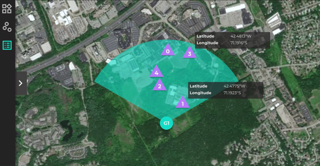
MatrixSpace Radar can be deployed as a collection of ground-based nodes to cover a wider area or as a single radar for specific coverage, including remote, unattended use.
The small, lightweight radar provides a full 360-degree perspective of any area for a complete field of view. The radar’s low energy consumption means it can be powered by solar or battery for usage where infrastructure is inaccessible or may not exist.
It integrates easily into industry-wide systems, such as traffic flow management, UTM, counter UAS and video surveillance systems.
Get 24/7 detection and reduce the need to send out staff to assess potentially dangerous situations.
Applications
For first responders, secure air space from rogue drones immediately – malicious or not – during accidents, disasters, outages and crimes.
Oversee major crowds – sporting events, parades or demonstrations – to ensure public safety.
Cue other sensors to the presence of threat aircraft with accurate 4D location.
Featured Video
BVLOS Intruder Drone Scenario
Fast, Easy and Flexible
(Front) Only 14.1cm in Length
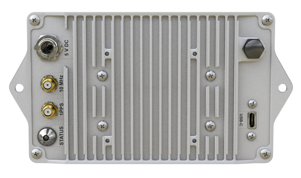
(Back) Only 8.7cm in Height

(Side) Only 4.2cm Wide
Learn more about MatrixSpace Radar and request product information
Sign up for our newsletter:
www.staging-matrixspace.kinsta.cloud
These Terms govern the use of this Application, and, any other related Agreement or legal relationship with the Owner in a legally binding way. Capitalized words are defined in the relevant dedicated section of this document.
The User must read this document carefully
This Application is provided by:
MatrixSpace
141 South Bedford Street
Burlington, MA 01803
Owner contact email: info@matrixspace.com
What the User should know at a glance
TERMS OF USE
Unless otherwise specified, the terms of use detailed in this section apply generally when using this Application.
Single or additional conditions of use or access may apply in specific scenarios and in such cases are additionally indicated within this document.
By using this Application, Users confirm to meet the following requirements:
Content on this Application
Unless where otherwise specified or clearly recognizable, all content available on this Application is owned or provided by the Owner or its licensors.
The Owner undertakes its utmost effort to ensure that the content provided on this Application infringes no applicable legal provisions or third-party rights. However, it may not always be possible to achieve such a result.
In such cases, without prejudice to any legal prerogatives of Users to enforce their rights, Users are kindly asked to preferably report related complaints using the contact details provided in this document.
Access to external resources
Through this Application Users may have access to external resources provided by third parties. Users acknowledge and accept that the Owner has no control over such resources and is therefore not responsible for their content and availability.
Conditions applicable to any resources provided by third parties, including those applicable to any possible grant of rights in content, result from each such third parties’ terms and conditions or, in the absence of those, applicable statutory law.
Acceptable use
This Application and the Service may only be used within the scope of what they are provided for, under these Terms and applicable law.
Users are solely responsible for making sure that their use of this Application and/or the Service violates no applicable law, regulations or third-party rights.
Common provisions
No Waiver
The Owner’s failure to assert any right or provision under these Terms shall not constitute a waiver of any such right or provision. No waiver shall be considered a further or continuing waiver of such term or any other term.
Service interruption
To ensure the best possible service level, the Owner reserves the right to interrupt the Service for maintenance, system updates or any other changes, informing the Users appropriately.
Within the limits of law, the Owner may also decide to suspend or terminate the Service altogether. If the Service is terminated, the Owner will cooperate with Users to enable them to withdraw Personal Data or information in accordance with applicable law.
Additionally, the Service might not be available due to reasons outside the Owner’s reasonable control, such as “force majeure” (eg. labor actions, infrastructural breakdowns or blackouts etc).
Service reselling
Users may not reproduce, duplicate, copy, sell, resell or exploit any portion of this Application and of its Service without the Owner’s express prior written permission, granted either directly or through a legitimate reselling program.
Intellectual property rights
Without prejudice to any more specific provision of these Terms, any intellectual property rights, such as copyrights, trademark rights, patent rights and design rights related to this Application are the exclusive property of the Owner or its licensors and are subject to the protection granted by applicable laws or international treaties relating to intellectual property.
All trademarks — nominal or figurative — and all other marks, trade names, service marks, word marks, illustrations, images, or logos appearing in connection with this Application are, and remain, the exclusive property of the Owner or its licensors and are subject to the protection granted by applicable laws or international treaties related to intellectual property.
Changes to these Terms
The Owner reserves the right to amend or otherwise modify these Terms at any time. In such cases, the Owner will appropriately inform the User of these changes.
Such changes will only affect the relationship with the User for the future.
The continued use of the Service will signify the User’s acceptance of the revised Terms. If Users do not wish to be bound by the changes, they must stop using the Service. Failure to accept the revised Terms, may entitle either party to terminate the Agreement.
The applicable previous version will govern the relationship prior to the User’s acceptance. The User can obtain any previous version from the Owner.
Assignment of contract
The Owner reserves the right to transfer, assign, dispose of by novation, or subcontract any or all rights or obligations under these Terms, taking the User’s legitimate interests into account. Provisions regarding changes of these Terms will apply accordingly.
Users may not assign or transfer their rights or obligations under these Terms in any way, without the written permission of the Owner.
Contacts
All communications relating to the use of this Application must be sent using the contact information stated in this document.
Severability
Should any provision of these Terms be deemed or become invalid or unenforceable under applicable law, the invalidity or unenforceability of such provision shall not affect the validity of the remaining provisions, which shall remain in full force and effect.
This Application (or this Application)
The property that enables the provision of the Service.
Agreement
Any legally binding or contractual relationship between the Owner and the User, governed by these Terms.
Owner (or We)
Indicates the natural person(s) or legal entity that provides this Application and/or the Service to Users.
Service
The service provided by this Application as described in these Terms and on this Application.
Terms
All provisions applicable to the use of this Application and/or the Service as described in this document, including any other related documents or agreements, and as updated from time to time.
User (or You)
Indicated any natural person or legal entity using this Application.
Latest update: July 20, 2021
www.staging-matrixspace.kinsta.cloud
This Application collects some Personal Data from its Users.
Personal Data collected for the following purposes and using the following services:
Advertising:
Google Ad Manager
Personal Data: Tracker; Usage Data
Analytics
Google Analytics, WordPress Stats and Google Analytics with anonymized IP
Personal Data: Tracker; Usage Data
Google Analytics for Firebase
Personal Data: geography/region
Google Analytics Advertising Reporting Features
Personal Data: Tracker; unique device identifiers for advertising (Google Advertiser ID or IDFA, for example); various types of Data as specified in the privacy policy of the service
Google Analytics Demographics and Interests reports
Personal Data: Tracker; unique device identifiers for advertising (Google Advertiser ID or IDFA, for example)
Simple Analytics
Personal Data: device information; language; Usage Data
YouTube Analytics and Reporting API
Personal Data: Data communicated in order to use the Service
Contacting the User
Contact Form
Personal Data: email address; first name; last name; phone number; physical address; ZIP/Postal code
Mailing list or newsletter
Personal Data: company name; email address; first name; last name
Content performance and features testing (A/B testing)
Google Optimize and Google Optimize 360
Personal Data: Tracker; Usage Data
Displaying content from external platforms
Google Maps widget
Personal Data: Tracker; Usage Data
Managing contacts and sending messages
Mailchimp
Personal Data: email address; first name; last name
Platform services and hosting
WordPress.com
Personal Data: Usage Data
Registration and authentication
WordPress.com Single Sign On
Personal Data: Tracker; various types of Data as specified in the privacy policy of the service
Remarketing and behavioral targeting
Google Ad Manager Audience Extension
Personal Data: Tracker; Usage Data
Further information about Personal Data
CCPA Cookie (usprivacy)
CCPA Cookie (usprivacy) is set by the Cookie Solution and stores California consumer opt-out choices in the local domain.
Cookie Solution (consent Cookie)
Consent Cookie (_iub_cs-X) is set by the Cookie Solution and stores User preferences related to Trackers in the local domain.
Preference Cookies.
Preference Cookies store the User preferences detected on this Application in the local domain such as, for example, their timezone and region.
Rights for registered California Users under the age of 18.
California’s “Online Eraser” law, part of California’s Business and Professions Code Sections 22580-22582, requires operators of certain websites and online services targeting minors to allow registered Users who are under the age of 18 and residents of California to request removal of content they post.
If a registered User fits that description and posted content on this Application, they may request removal of such content by contacting the Owner or its privacy policy coordinator at the contact details provided in this document.
In response to this request, the Owner may make content posted by the registered User invisible to other registered Users and the public (rather than deleting it entirely), in which case the content may remain on the Owner’s servers. It may also be publicly available elsewhere if a third party copied and reposted this content.
Selling goods and services online.
The Personal Data collected are used to provide the User with services or to sell goods, including payment and possible delivery.
The Personal Data collected to complete the payment may include the credit card, the bank account used for the transfer, or any other means of payment envisaged. The kind of Data collected by this Application depends on the payment system used.
sessionStorage.
sessionStorage allows this Application to store and access data right in the User’s browser. Data in sessionStorage is deleted automatically when the session ends (in other words, when the browser tab is closed).
Contact information
Owner and Data Controller
MatrixSpace
141 South Bedford Street
Burlington, MA 01803
Owner contact email: info@matrixspace.com